
When I first arrived in Sydney as a 20-y-o in the early ‘80s, my work immediately required me to drive all across the city, day and night. Coming from quiet and orderly Adelaide, I often joked that I needed to learn how to drive all over again. The road system and culture was a whole other experience.
Today, out of choice as much as economics, I drive much less and it is very interesting to revisit locations I recall from 30 years ago and see how they are vastly changed. I’m sure older Sydney natives will notice this even more than I.
One road I used to dread, was driving out of the CBD across the Glebe Island bridge. There always seemed to be a jam which was exacerbated enormously if the cantilever had to swing for someone’s yacht that was six inches too tall.
Now that the vastly overengineered Anzac Bridge has replaced the old swing Allan truss road bridge in 1995, the poor old thing lies with its electrically operated span permanently agape like some prostrate beast slain and left to rot.

I recently threw caution to the wind and walked out on the old southern roadway for a closer look. All access is closed, of course, so a bit of youthful ‘gibbonry’ was required to scale the rusty cyclone fencing. It was sad to see weeds sprouting up through cracks in the roadway and the old wooden gates, paint peeling, dangling from rusted hinges.
The plaque, installed during the bridge construction in 1903 reads:
“THIS BRIDGE WAS OPENED FOR TRAFFIC BY THE HON. SIR JOHN SEE KCMG PREMIER OF NEW SOUTH WALES JULY 1ST 1903 HON E W O’SULLIVAN MINISTER FOR WORKS”
In fact, the bridge was quite the engineering marvel of its time and featured in a supplement of "The Scientific American" on February 6, 1904.
I note that many future uses are being discussed such as cyclists, pedestrian and even light rail connections to Balmain and Rozelle. Cruise passengers, assuming the industry recovers, would also find this a most useful service. It’s also listed on several historic registers, so its preservation in some form seems likely.
More: https://www.glebeislandbridge.com/
Facts on the current ANZAC Bridge
- Location: The Anzac Bridge spans Johnstons Bay between Pyrmont and Glebe Island (part of the suburb of Rozelle), on the western fringe of the Sydney central business district.
- Description: The Anzac Bridge is an eight-lane cable-stayed bridge that carries the Western Distributor (A4).
- History: The first bridge was built in 1862 and was a timber beam bridge. The second bridge, an electrically operated swing bridge, opened in 1903. The current Anzac Bridge was opened to traffic on December 3, 1995, and was given its current name on Remembrance Day in 1998 to honor the memory of the soldiers of the Australian and New Zealand Army Corps (Anzacs) who served in World War I.
- Design and Construction: The stay cable design concept development and final design for the new bridge were carried out by a team from the Roads & Traffic Authority. The bridge was built in 10-meter concrete segments, with each segment cast on the land side balanced by casting an equal one over the water. The segments each weighed about 460 tonnes. The bridge has a main span of 345 meters and a total length of over 800 meters. From the two 120-meter high towers, 128 stay cables support the reinforced concrete deck.
- Features: The bridge has a grade-separated shared pedestrian footpath and cycleway located on the northern side. There is a speed limit of 60 kilometers per hour (37 miles per hour) on the bridge. The bridge can carry a maximum of 180,000 cars per day.
- Memorials: A bronze memorial statue of an Australian Anzac soldier ("digger") holding a Lee–Enfield rifle in the "rest on arms reverse" drill position was placed on the western end of the bridge on Anzac Day in 2000. A statue of a New Zealand soldier was added to a plinth across the road from the Australian Digger, facing towards the east, and was unveiled by Prime Minister of New Zealand Helen Clark in the presence of Premier of New South Wales Morris Iemma on Sunday, April 27, 2008.
- Impact: The bridge has been used in a number of artistic works, including the movie "Looking for Alibrandi" and songs by Deni Hines and You Am I. It has also been a key link between Sydney City and the suburbs to the west, providing a major east-west route to the western suburbs and the M4 motorway to the Blue Mountains.
 |
| Present-day Anzac Bridge under construction c.1993. Traffic over the old Glebe Island Bridge can be seen right of frame (Newscorp) |
Today, out of choice as much as economics, I drive much less and it is very interesting to revisit locations I recall from 30 years ago and see how they are vastly changed. I’m sure older Sydney natives will notice this even more than I.
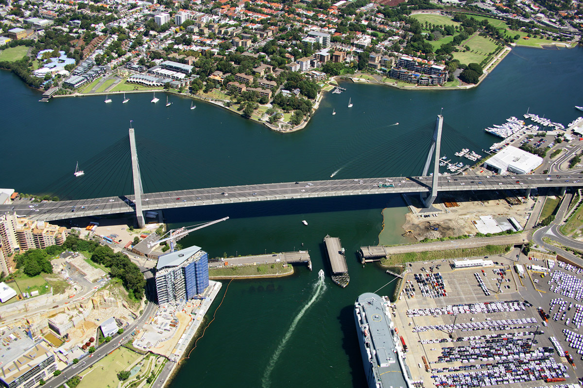 |
| Present-day Anzac Bridge showing disused Glebe Island Bridge (Airview via Dictionary of Sydney) |
One road I used to dread, was driving out of the CBD across the Glebe Island bridge. There always seemed to be a jam which was exacerbated enormously if the cantilever had to swing for someone’s yacht that was six inches too tall.
Now that the vastly overengineered Anzac Bridge has replaced the old swing Allan truss road bridge in 1995, the poor old thing lies with its electrically operated span permanently agape like some prostrate beast slain and left to rot.
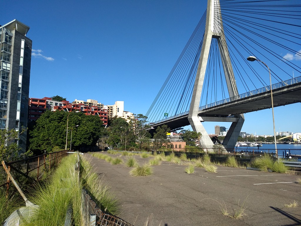 |
| The southern (Pyrmont) roadway. April 2020. (Roderick Eime) |
I recently threw caution to the wind and walked out on the old southern roadway for a closer look. All access is closed, of course, so a bit of youthful ‘gibbonry’ was required to scale the rusty cyclone fencing. It was sad to see weeds sprouting up through cracks in the roadway and the old wooden gates, paint peeling, dangling from rusted hinges.
 |
| Inauguration plaque (Roderick Eime) |
“THIS BRIDGE WAS OPENED FOR TRAFFIC BY THE HON. SIR JOHN SEE KCMG PREMIER OF NEW SOUTH WALES JULY 1ST 1903 HON E W O’SULLIVAN MINISTER FOR WORKS”
In fact, the bridge was quite the engineering marvel of its time and featured in a supplement of "The Scientific American" on February 6, 1904.
I note that many future uses are being discussed such as cyclists, pedestrian and even light rail connections to Balmain and Rozelle. Cruise passengers, assuming the industry recovers, would also find this a most useful service. It’s also listed on several historic registers, so its preservation in some form seems likely.
 |
| One suggestion for future use |
More: https://www.glebeislandbridge.com/
Facts on the current ANZAC Bridge
- Location: The Anzac Bridge spans Johnstons Bay between Pyrmont and Glebe Island (part of the suburb of Rozelle), on the western fringe of the Sydney central business district.
- Description: The Anzac Bridge is an eight-lane cable-stayed bridge that carries the Western Distributor (A4).
- History: The first bridge was built in 1862 and was a timber beam bridge. The second bridge, an electrically operated swing bridge, opened in 1903. The current Anzac Bridge was opened to traffic on December 3, 1995, and was given its current name on Remembrance Day in 1998 to honor the memory of the soldiers of the Australian and New Zealand Army Corps (Anzacs) who served in World War I.
- Design and Construction: The stay cable design concept development and final design for the new bridge were carried out by a team from the Roads & Traffic Authority. The bridge was built in 10-meter concrete segments, with each segment cast on the land side balanced by casting an equal one over the water. The segments each weighed about 460 tonnes. The bridge has a main span of 345 meters and a total length of over 800 meters. From the two 120-meter high towers, 128 stay cables support the reinforced concrete deck.
- Features: The bridge has a grade-separated shared pedestrian footpath and cycleway located on the northern side. There is a speed limit of 60 kilometers per hour (37 miles per hour) on the bridge. The bridge can carry a maximum of 180,000 cars per day.
- Memorials: A bronze memorial statue of an Australian Anzac soldier ("digger") holding a Lee–Enfield rifle in the "rest on arms reverse" drill position was placed on the western end of the bridge on Anzac Day in 2000. A statue of a New Zealand soldier was added to a plinth across the road from the Australian Digger, facing towards the east, and was unveiled by Prime Minister of New Zealand Helen Clark in the presence of Premier of New South Wales Morris Iemma on Sunday, April 27, 2008.
- Impact: The bridge has been used in a number of artistic works, including the movie "Looking for Alibrandi" and songs by Deni Hines and You Am I. It has also been a key link between Sydney City and the suburbs to the west, providing a major east-west route to the western suburbs and the M4 motorway to the Blue Mountains.
Other bridges in this series:


No comments:
Post a Comment