April 29, 2020

History on the Harbour: Mort's Dock, Balmain

The maritime history of Sydney and Port Jackson is well known to many, but hidden away in the many nooks, crannies and alcoves around the harbour are the smaller stories that tend to be lost to time. The former Mort's Dock at Balmain is one such story.

Boys play unaware of the history on which they stand (Roderick Eime)

On a recent canoe exploration around Balmain and Birchgrove with guide Mike Butler and I happened upon some abandoned infrastructure along the shore adjacent to the Balmain ferry wharf. I joked that it looked like a submarine pen, but it was enough for us to want to investigate further.

April 27, 2020

Vale Mike Osborne


It is with much sadness that we bid a final farewell to our dear colleague and friend, Michael Osborne, who slipped away peacefully while in hospital following surgery.

For many years, Mike was a fixture at travel industry functions and an inveterate traveller and always generous with his time and advice.

Mike was one of the first people I met when I transitioned to fulltime travel writing around 20 years ago and will always remember his good humour and ebullient personality. We travelled together on many occasions and he was invariably an excellent travelling companion.

He leaves a legacy of voluminous travel writing and pictures through his website, Mature Traveller.

Cheers, Mike. Travel well and thanks for all the fish. 

Roderick Eime

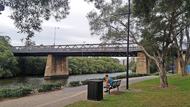
Sydney Harbour Bridges: The Gasworks Bridge, Parramatta

Gasworks Bridge Parramatta (Roderick Eime)

While technically this bridge is not on the 'harbour' exactly, it still crosses the primary waterway that feeds into Port Jackson, namely the Parramatta River. Ferries en route to Parramatta from Circular Quay cross under it daily.

A few hundred metres away is Australia's oldest surviving building, the 1793 Elizabeth Farm of famous pioneer, John Macarthur, so the historic Gasworks Bridge is in good company.


Parramatta Gasworks showing bridge to right of frame. The gasworks opened in 1873.

Today, the iron lattice bridge still conveys hundreds of vehicles of a type it could never have imagined when it was erected in 1885 using a design by the prominent civil engineer, John A McDonald, a Public Works colleague of Percy Allen who designed both the 1903 Glebe Island Bridge and the Pyrmont Bridge.

Drone shot facing east from the southern bank. April 2020 (Roderick Eime)

The iron lattice design was popular throughout the British Empire in the late Victorian era and examples can be seen around Australia and other colonies. It was initially a little more expensive to construct but used less iron than comparable and heavier cellular girder bridges and have stood the test of time. More than 30 such bridges were built in NSW between 1870 and 1893, another example being the Meadowbank Railway Bridge.

The structure is registered with the NSW State Heritage Register for historic, aesthetic and social significance.

April 25, 2020

Sydney Harbour Bridges: The Glebe Island Bridge

When I first arrived in Sydney as a 20-y-o in the early ‘80s, my work immediately required me to drive all across the city, day and night. Coming from quiet and orderly Adelaide, I often joked that I needed to learn how to drive all over again. The road system and culture was a whole other experience.

Present-day Anzac Bridge under construction c.1993. Traffic over the old Glebe Island Bridge can be seen right of frame (Newscorp)

Today, out of choice as much as economics, I drive much less and it is very interesting to revisit locations I recall from 30 years ago and see how they are vastly changed. I’m sure older Sydney natives will notice this even more than I.

April 24, 2020

History on the Harbour: An indigenous perspective


The European history of Sydney Harbour is a mere 230 years old, but human habitation in Port Jackson extends thousands of years prior.

Many of us would have heard speeches prefaced with the paying of respect to the Gadigal people of Sydney, who were once numerous all around the harbour. But I wonder how many have a chance to see Sydney Harbour through their eyes.

Clevelley and Prattent, View of Port Jackson, c1789.
Wood engraving, hand coloured, published 1789. Manly art Gallery & Museum collection


“This is what we try to give people,” Mike Butler of Sydney Harbour ElderTours tells me. “Thousands and thousands of years before the First Fleet this is how Sydneysiders lived on the harbour. And there’s still no better way to enjoy it.”

With the establishment of Sydney as a prison outpost in 1788, Port Jackson soon became the epicentre for European and Aboriginal cross-cultural interaction - and all that that entailed - as it became an important and expanding Imperial colony.

Goat Island showing its location from Millers Point (in the top right) and East Balmain (top left) : Pic: Fairfax

“We have a bloke called Watkin Tench to thank for his two books on the early days of the colony,” Mike continues, “along with a lot of other material that gives fascinating insights on the Aboriginal experience since then.”

Those early interactions included an aggressive outbreak of smallpox that had a devastating effect throughout the harbour. Some historians argue this was a deliberate rerun of biological warfare used so effectively on American Indians the decade before. Tench even makes mention of vials of smallpox pathogen being carried on the First Fleet.

Mike Butler can show you a side a Sydney rarely seen by even residents (Roderick Eime)

“But it’s a mistake to think Aboriginals disappeared from here. The reality is Aboriginal people continued here and they’re still here today,” he smiles teaching me the Gadigal word 'Ngarangun': to learn together, think together and listen together.

“Ngarangun. We’re doing that right now,” he says as we paddle his well-worn canoe around the shore from under ANZAC Bridge, past Peacock Point to Goat Island. We circumnavigate this seldom-visited little island, now returned to Aboriginal ownership, but still administered and protected by NSW Parks.

“My local mob say the closer you are to water, the greater the pleasure,” says Mike - something that succinctly describes Sydney’s waterfront lifestyle to a tee.

Goat Island, also known by its Aboriginal name ‘Me-Mel’, is the closest harbour island from Barangaroo, about 500m to the northwest of Millers Point and a little over 100m from East Balmain. Beginning as a sandstone quarry, it later became the site of the colony’s first arsenal and explosives store and once housed Sydney Water Police headquarters, a role it revived for the TV series, Water Rats, in the late ‘90s.

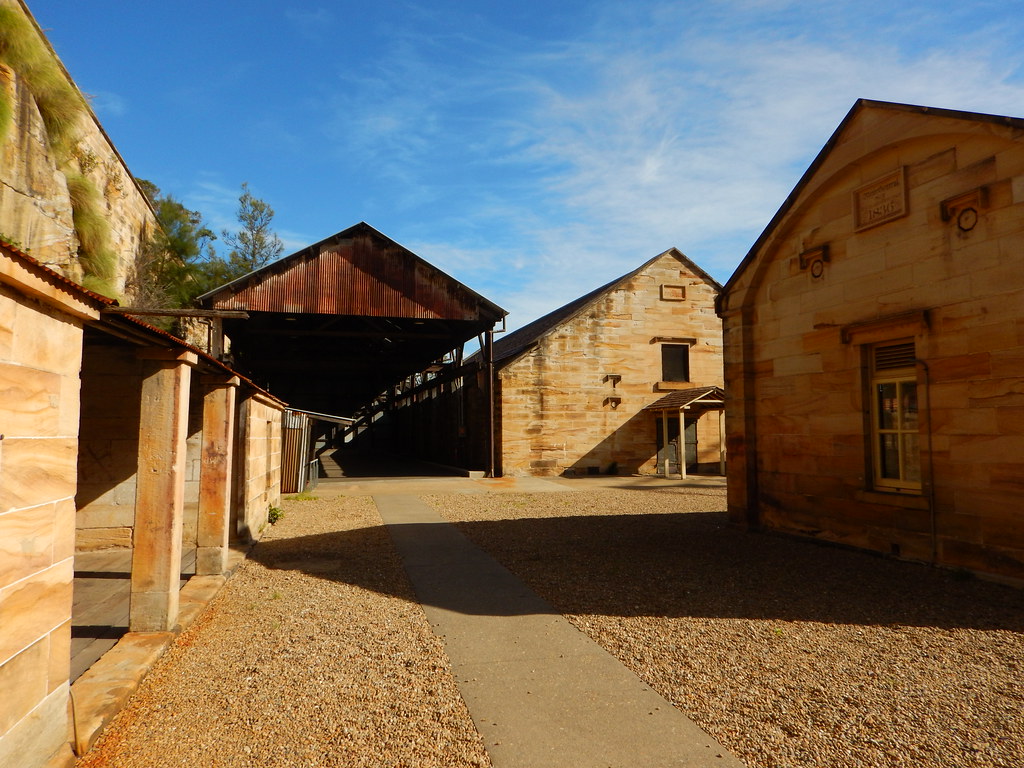
This cluster of early sandstone buildings dates back to 1836 (Roderick Eime)

Mike, who has lived around the harbour for 40 years, has privileged access to the island and can escort guests around some of the historic structures that are preserved on the island, free from marauding vandals and mercifully graffiti-free, save for some chiselled mementoes that date back to the time the stoneworks were first erected.

Past visitors have inscribed themselves into history (Roderick Eime)

The earliest European building is conspicuously marked by a stone engraved with the name of Sir Richard Bourke, 1836. Bourke was the eighth Governor of New South Wales, in office from 1831-37 and oversaw the conversion of Goat Island to a storage facility for gunpowder and other ordnance. It’s his statue that stands outside the State Library.

It is thought that the famous Aboriginal couple, Bennelong and Barangaroo, lived on the island at various times in the colony’s early days. Goat Island is still used today as a private marine maintenance facility and slipway under a giant hammerhead crane built in the 1920s.


April 18, 2020

WA’s Coral Coast: West ‘n’ Wild


Bleak and bereft to the untrained eye, the wonders of Western Australia’s Coral Coast are now front-and-centre on the world ecotourism stage. Ocean’s Roderick Eime sails aboard True North for an intimate look at our extraordinary Western shore.

“There she is!” cried Greg our champion fisherman. His trained eyes, aided by Polaroid sunglasses, spotted the telltale wake on the shimmering sea. It was just a ripple at first, but soon looked like a midget submarine just beneath the surface. “She” was a magnificent whale shark, the world’s largest fish, and she was coming straight for us.

This beautiful and serene creature is at least partly responsible for the surge in interest in Western Australia’s Coral Coast. The other significant and established attraction is the wild dolphin viewing at Monkey Mia, but the bounty of activities and sightseeing opportunities on the Coral Coast just begins there.

The Coral Coast starts about 100 kilometres north of Perth and continues its upward sweep beyond the continent’s westernmost extremity at Steep Point, to Exmouth and the famous Ningaloo Reef, a distance of around 1200 kilometres. Its name, as you’ve already deduced, is derived from the rich coral formations along its length, unusual because they exist so far south.

Fed by the warm, southward flowing Leeuwin Current, the water is kept constant at about 20 to 22 degrees allowing the formation of coral and the growth of seagrass. Bright, colourful tropical fish abound in the waters where they really shouldn’t and the clash of northward currents create a rich mix of nutrients that make for great fishing and big lobsters.

Swimming with whale sharks (Tourism Australia)

This expansive region is itself divided into smaller parcels, popularly known as the Turquoise, Batavia and Outback Coasts.

I set out to explore this region aboard one of the only vessels offering a comprehensive cruise itinerary in the region: North Star Cruises’ smart new 36-passenger expedition yacht, True North II. She travels this route but once a year as she return s to her home port of Broome from Fremantle to begin the busy Kimberley cruise season.

The Turquoise Coast is the first region we encountered and is an easy drive or sail from the city of Perth and dotted with popular weekend attractions for Perth locals looking for a short getaway. The iconic landmark of the region is the famous ‘pinnacles’ in the Nambung National Park, four kilometres inland. Although the pinnacles were not on our itinerary, a previous visit brought home the highly unusual spectacle of these limestone and quartz formations. In the evolutionary scheme of things, these bizarre natural objects are a brief quirk in this slow but dynamic desert landscape.

Other regional highlights include the Jurien Bay colony of noisy Australian Sea Lions and the wild colours of the Yarra Yarra Salt Lakes that create brilliant hues of pink, red and purple in the setting sun.


Our first stop en route north is the unassuming and outwardly unexciting Houtman Abrolhos Islands. Located about 60 kilometres offshore from Geraldton, the bleak flat islands were little comfort for the Batavia survivors who endured unimaginable hardships during their months of isolation here in 1629. Authorities believe there are almost twenty wrecks dotted around the islands

Today the islands are decorated with clusters of fishing huts for the itinerant crayfish hunters and recreational fishermen. A memorial and plaque stands testament to its brutal past.

The Batavia Coast is home to several land-based curiosities, including the world famous micronation, Hutt River Province about 30 kilometres inland from Gerladton. Visit Prince Leonard of Hutt and pick up a knighthood while you’re there. HRH celebrates thirty seven years on the throne this year. Onya Len!

The regional hub is the town of Geraldton. Rich with maritime history, the town of 30,000 is a thriving business and tourism centre. Windsurfing, fishing, diving, surfing and swimming are all popular watersports here.

Overlooking the city centre is the recently completed HMAS Sydney Memorial which serves as a poignant reminder to another nearby naval tragedy, that of the loss of Australia’s flagship in November 1941 in a battle with the German commerce raider Kormoran.

Beyond the Batavia Coast and her many distractions, we venture to the pristine waters of Shark Bay and the namesake marine park that is home to the famous wild dolphins of Monkey Mia and the mysterious whale sharks. Ashore we explore Steep Point, taking delight in the knowledge we are the most westerly humans on the continent for a few moments.

True North lingers in the region, now known as the Outback Coast, long enough for us to explore parts of Dirk Hartog Island, Turtle Bay, Bernier Island, Norwegian Bay and the nominal home of the whale shark, Ningaloo Reef.

Shark Bay is truly an Australian tourism jewel and is now recognised as a World Heritage site by UNESCO for its natural treasures. Access for cruise vessels like True North is limited and we must do the bulk of our exploring in the tenders, such is the determination of WA’s Department of Conservation to protect this region.

The towns of Denham, Carnarvon and Monkey Mia have expanded considerably over the last decade as the reputation of this area has spread. Once a casual and leisurely affair, the iconic wild dolphin-feeding at Monkey Mia is now strictly managed by rangers who are determined to retain the very special experience, but not corrupt the beautiful creatures with over-indulgence. Apart from the celebrity dolphins, mighty manta rays, huge humpback whales, docile dugongs and squadrons of seabirds patrol this ecologically abundant body of water at various times.

Now (April – July) is Whale Shark season. These magnificent creatures, the world’s largest fish, congregate offshore from the Cape Range National Park each year. Around Exmouth and particularly Ningaloo Reef, are the only locations in the world where their presence can be guaranteed and their habits studied by marine scientists. Just where they go in the meantime is still a mystery.

Greg stopped shouting and was just pointing now as the massive aquatic beast neared our little fishing dinghy. We’d been busily hauling in a rewarding catch of snapper for tonight’s dinner when the apparition appeared. Just when I thought I’d drop the rod and dive in with the animal, it dived. The four of us scoured the sea for another fifteen minutes and were even joined by another tender also on the lookout, but she’d gone as suddenly and mysteriously as she had arrived.

Swimming with whale sharks, it should be noted, is also now strictly controlled with licenses issued to a limited number of operators, all of whom are based in the village of Coral Bay north of Carnarvon. If a stray animal stumbles on you when you are out fishing, well that’s just good luck. Regardless, swimming with them is governed by laws that forbid you from approaching closer than 3 metres. Boats must maintain a 250 metre distance.

Our 10-day mini-odyssey finishes in Dampier, but not before we explore the remote and forlorn Monte Bello Islands, once the site of British nuclear tests in the 1950s. In one test, a war surplus frigate was vaporised by a 25 kiloton device detonated beneath its hull. Warning signs are still erected on the beach where loggerhead turtles have returned to nest and a rusty jeep lies hidden in the dunes, once too radioactive to recover.

Disguised as rugged and inhospitable, Western Australia’s Coral Coast successfully deterred all but the most determined explorers for hundreds, even thousands of years. Only now is its exquisite and very special natural beauty being fully appreciated by the conservation conscious and eco-tourists in search of new and rewarding destinations.
DOING IT:


Originally published in Ocean Magazine. March 2007.

April 15, 2020

Hermannsberg NT: History in the desert


How would you feel if a spaceship landed in your backyard? Shocked, frightened, overwhelmed? I imagine that’s how the Arrernte people of central Australia felt when confronted with the arrival of Europeans in the middle of the 19th century. After more than 30,000 years occupying the region around present-day Alice Springs and the MacDonnell Ranges, the Arrernte were suddenly displaced from large parts of their lands and traditions.

Among the earliest European arrivals were German Lutheran missionaries. They arrived in 1877 after an 18-month, 2000km trek from Adelaide with a herd of cattle and a large flock of sheep. The Lutherans built a church, some houses and a school beside the Finke River, calling their mission Hermannsburg (Ntaria in Arrernte) after their home town.

Today 138 years later, it still has the feel of a dusty outback settlement, and, although it represents European attempts to bring a distant notion of ‘civilisation’ to an ancient indigenous culture, Hermannsburg has an ethereal beauty. Fully restored in 1988 under a Bicentennial grant, the mission has great historical significance as central Australia’s first town.

As I walk across the red dirt compound towards the whitewashed church, I’m struck by the incongruous nature of the architecture in this central desert setting. A dozen whitewashed buildings of various sizes radiate at a distance from the church, which is shaded by red river gums. Date palms feature in some sections.


Wandering through the heritage-listed buildings evokes a range of emotions. Life was obviously difficult for everyone here, but I wonder about conditions for the Aboriginal people. One description from 1923 quoted in an Australian Human Rights Commission report refers to 25 boys and 30 girls sleeping on sand spread over the floor in separate dormitories at Hermannsburg: ‘The hygienic state of these dungeons during the extremely hot summer nights can better be imagined than described.’

On the one hand, the narrative of is about determined German missionaries enduring incredible hardship and isolation in their quest to establish a mission and convert the Arrernte to Christianity.

On the other hand, the Arrernte people were confronting the colonial reality of missionaries and pastoralists taking over their land. The pastoralists had the backing of the police in most instances and historians record that the practice of shooting Aborigines ‘with impunity’ was widespread.

But at this point, the colonial stereotype of ‘a Bible in one hand and a gun in the other’ breaks down. Although repugnant mission practices such as the separation of children from their parents took place at Hermannsburg, it nevertheless became a vital sanctuary for the Arrernte people against the widespread frontier violence of the time. The austere Lutheran clergy stood up to white station owners and the police, protecting the Arrernte on Hermannsburg’s 3750sq.km leasehold.

After 16 years of tough outback life, the first missionaries left and were replaced in 1894 by Carl Strehlow, whose achievements include translating the New Testament into Arrernte. Carl’s son Ted grew up with the local Arrernte dialect as a first language and went on to become one of the country’s most prominent anthropologists. Accepted as a tribal member, Ted Strehlow wrote the classic Songs of Central Australia by transcribing the poetic ceremonial chants of Arrernte elders.

Despite being discouraged by the missionaries from following traditional ways, many Arrernte secretly received tribal initiation. Because of this, Arrernte culture remains strong to this day.

Perhaps the most significant early fusion of western painting techniques and Aboriginal vision came in the artwork of Hermannsburg resident Albert Namatjira. His depictions of the central desert landscapes taught a white majority to see the desert as truly beautiful rather than as an arid wasteland. There’s an interesting gallery in one of the mission buildings featuring works by other artists who adopted Namatjira’s approach. Distinctive Hermannsburg pottery is also on sale at the mission shop.

Visiting Hermannsburg, which has been in Aboriginal ownership since 1982, is a rare chance to wander around a faithfully restored site, see some remarkable art and pottery, enjoy tea and scones at the Kata Anga Tea Rooms and drink in the incredible sense of history that makes the outback another world.

Getting there:

Head west from Alice Springs on Larapinta Drive.
Distance: 125kms - road sealed entire journey.
Turn right into Hermannsburg and proceed to the T-intersection.
Turn left and follow the road for approximately 800 metres.
Carpark and Historic Precinct is on your left.
===

Originally published in Get Up & Go Magazine - Autumn 2016

April 13, 2020

Hiroshima: City of Peace


8:15 am on 6 August 1945 was the moment the world changed forever. It was at this time Hiroshima became the target of the world’s first atomic bomb attack. This August commemorates 70 years since that devastating attack, which effectively brought an end to WWII in the Pacific.

April 10, 2020

Penang: Where the streets have many names

Penang. Photo by Yaopey Yong on Unsplash


The UNESCO World Heritage City of George Town in Penang is a place where the streets have many names. Charming. quixotic and evocative - and in Hokkien, Cantonese, Malay and Tamil. These colloquial nuggets make for a perfectly quirky way to explore its rich multicultural streets.

Words: Eugene Ng. Reproduced with kind permission of Malaysia Airlines

Penang Street: Yeap, he's rich

The reason why the local Hokkiens call a section of Penang Street kau keng choo (nine houses) is a testament to the Chinese reverence for wealth and status. ln the '1 8BOs, a row of nine opulent townhouses stood at the northern end of the road. This was then considered a prestigious address, as it was close to the 'European District' and thus a status symbol. Yeap Chor Ee built nine houses here. ln a row. Hence the name of the street. 

Today, only three of those nine shophouses remain in its full Straits Eclectic splendour and they front The House of Yeap Chor Ee (4 Penang Street Tel +604264 50BB Opens 1 1 .30am-3pm, 6-l0.30pffit6.losedSundays), a museum gallery set up in tribute by one of the founder's grandsons, Dato Sri Steven Yeap. The family once lived in these very houses but they now contain the family's ancestral tablets and some fine examples of Straits Chinese furniture and antiques. Yeap Chor Ee was the only man to have ever single-handedly funded the establishment of a bank in that era, Ban Hin Lee Bank. 

You have to enter the museum through The Sire, located at the back on King Street, as only diners at this fine-dining Western restaurant are allowed free admission to the museum upstairs. And as if to further underline Yeap's legacy on the island, this section of King Street used to be called kau keng choo au (back of the nine houses). 

Back to Penang Street, do pop by Water Drop Tea House (1 6 Penang Street Tel +604 263 5300 Opens 9am- 5pm, till 3pm weekends, closed on Monday) for a vegetarian meal, tea or some Buddhist literature, As you walk south, you will come across a couple of smaller clan temples, then sadly, the now-defunct Yin Oi Tong (82A-82C Penang Street), the oldest Chinese medical hall in South East Asia (1796) before the street takes on a distinctly Indian flavour. The locals used to ll this section chetty kay (Chetty road) for obvious reasons, 

Right at the end, almost tucked away from sight, is the Nagore Shrine, a Tamil-Muslim memorial of a South Indian saint. And on the left of the shrine on the side of King Street, you can buy a traditional songkok from OSM Mohd Shariff (1 57, King Street Tel +604 263 1290), who still makes this religious Islamic headgear bent over an old-fashioned sewing machine; Haji Mohideen is the last songkok maker on the island 

Queen Street: let's get literal

It should be obvious by now that the Hokkiens were not particularly imaginative when it came to street naming. At the same time, it is not hard to be charmed by just how endearingly literal they could be. Queen Street used to be called chapiee keng choo (12 houses) for the 12 identical shophouses that apparently once stood here. The Malay name for the road, gedung rumput or grass warehouse, hints at another facet of its past. 

Queen Street today is a vibrant living street. lt ts predominantly lndian and has been for over two centuries with the epicentre being the Arulmigu Sri Maha Mariamman Temple, an 1833 South lndian Dravidian-style temple with a colourful gopuram (tower) that peeks out from above the rooftops. 

The street is also home to a couple oi the islandS surviving, craftsman of yore. M Thana's Goldsmith (36 Queen Street) still hand tools gold jewellery in traditional Indian designs. The jeweller, M Raju (who named the shop after his wife), is another dying breed, as unlike machined tooled jewellery, each piece that he creates is a unique labour of love, skill and passion

Peer into the workshop of Kok Ying Chow (41 Queen Street Tel +604 262 9754) and it might seem that time has stood still. In a darkened room, Chinese calligraphic wooden plaques lay stacked flat on the floor or up against the walls. At the front, the wizened signboard maker 'demonstrates his craft (if he is there for those who care to watch You can order one bearing your name (in Chinese) for around RM150. The calligrapher was one of the recipients of the Penang Heritage Trust-HSBC Living Heritage Treasure of Penang award so it will be a little bit of history in your hands.

Muntri Street Stewart Lanes: The streets illicit

As many of these street names are only remembered through oral history, there are a few whose origin or context are still debated about. Case in point: Muntri Street and Stewart Lane. Both have been referred to as 'Mistress Lane' though neither with any certainty or conviction

Walking from the west on Muntri Street, you will first come across the modest Hainan Association & Temple that dates back to 1895. This is a quiet street, with a lot of empty shophouses though many still have beautiful their Straits Eclectic facades intact (from the late 1800s and early 1900s). Jin Xiu Art Gallery and Tea House (58 Muntri Street) is housed in one of these shoplots Gorgeously restored, it serves Nyonya cuisine and is also in the business of promoting local Penang artists as well as specialty teas and its related paraphernalia

This street is also where two major Penang hospitals were founded. The first, Lam Wah Ee, was built in 1883 but destroyed during the Second World War but the older generation of Hokkiens still call the street Lam Wah Ee kay (street) in memory of it. The other, Adventist Hospital (1924), is now a hotel. Many trade guilds and associations like the Association of Chinese Physicians (71 Muniri Street) also made their home here as did famous 19th-century Baba-Malay novelist Chan Kim Boon or Batu Gantong (1851-1920) who lived in No 75.

Muntri Street leads straight into Stewart Lane whose main and only - point of interest is the fabulous new boutique hotel Straits Collection (47-55 Stewart Lane, 89-95 Armenian Street Tel +604 263 7299 www.straitscollection.com.my). Owned and managed by the folks from Bon Ton Resort and Temple Tree in Langkawi, this is the perfect way to completely immerse yourself in the whole George Town experience. Comprising nine shophouses in all (with four at nearby Armenian Street), this part of the hotel features three three-bedroom suites, all a paragon of good solid restoration work and perfect examples of how modernisation and old-world charm can co-exist. Two others have been converted into The Reading Room, and Kopi Cine, a modern cafe serving coffees, frappes, cakes and fusion bistro-style dinners.

Armenian Street: A walk in time 

While Armenian Street's Hokkien name may be a little mundane, pak thang'a kay (copper beating road), this two-part street is one of the most charming in all of George Town. The four units of the Straits Collection here provide a far more quaint experience than at Stewart Lane if for the mere fact that this area is still active with the sights and sounds of normal everyday life. Of the four, the middle units are both complete houses while the two bookends have one-bedroom apartments above two retail outlets Bon Ton The Shop and China Joes.

The Sun Yat Sen Penang Base (120 Armenian Street Tel +604 262 0123 Opens 10am-2pm, closed on Sunday Admission RM3) is a major highlight here. It was only discovered as recently as 1992 that this very building was used by the 'father of modern China' Sun Yat Sen as his headquarters while here planning the Canton Uprising in 1910; an intriguing stop where hours can be spent as secrets and political intrigue from the past come tumbling out. 

The Penang Islamic Museum (128 Armenian Street Tel +604 262 0172 Opens 9am-5pm, closed Tuesdays Admission RM3 www.penangislamicmuseum.net) and the extraordinarily ornate Yap Kongsi and Ciji Temple (corner of Armenian and Cannon), are also worth a visit. The museum traces the history, development and influence of Islam in Penang, in and around the area of Acheen Street. The building in which it is housed the Syed Al-Attas Mansion - is also a fine example of mid-1800s Islamic architecture and was believed to have been used as a secret base for the Achehnese leaders during their fight against the Dutch. 

Khoo Kongsi (Tourism Malaysia)

Take a short detour onto Cannon Street to view the poster child of Penang tourism, Khoo Kongsi (18 Cannon Street Tel +604 261 4609 Opens 9am-5pm www.khookongsi.com.my), the most lavish and breathtaking of all the island's clan houses. Then continue along Armenian's wending ways and explore a host of new art galleries.

Or if you rather, get a further glimpse of Penang's golden past by making a pair of Nyonya Beaded Shoes (4 Armenian Street Tel +6016 454 3075) or get a shave at Hwa Bee Barbers (unnumbered, same row as Hock Teik Cheng Sin or Tua Pek Kong Temple) by possibly Malaysia's one and only lady barber who fiercely stared down our numerous requests to photograph her with a flick of her wrist.

== ++ ==

For guided walking tours of the island's major heritage sites, contact the Penang Heritage Trust (26 Church Street Tel +604 264 263'l www.pht.com.my), or simply pick up the ubiquitous George Town World Heritage Site Map, easily available from just about everywhere and explore by foot on your own. If you would like to know more about the old vernacular names of George Town streets, look out for the blue signboards (posted by the Penang Heritage Trust) at the start/end of each street which list all the known versions in various languages. 


April 06, 2020

Japan: 24 Hours in Tokyo

Tokyo. Aleksandar Pasaric / Pexels.com


From futuristic skyscrapers to ancient temples, and karaoke bars to sushi joints, Tokyo has it all and it's wrapped up in manic energy which is both energising and exhausting at the same time.

Words: Joanna Hall

On the first visit, this sprawling hyper urban metropolis can be overwhelming but armed with a one-day metro pass (most train and metro stations and maps are posted in English), it's possible to get out and about and see three or four major sights in a day, although if you really want to "go local" you'll double that number.

1 TSUKIJI FISH MARKET

Source: triphobo.com
If it comes from the ocean, then you'll find it here at Tokyo's central fish market which is near Ginza. Much of Tokyo's fish and seafood transits its cavernous halls, with some 14,000 retailers converging six days a week to sell their wares. It's a colourful, noisy, chaotic and a real-life workplace where workers yell, chop blocks of ice, make sushi, smoke, chatter, bone an eel, and then yell some more. More than 2000 tonnes of fish worth $15 million are sold here daily and if you're up for an early start (6am-1pm) then this is a fascinating introduction to Tokyo life. The scores of restaurants near the market serve the freshest sushi, which is a traditional Japanese breakfast.

2 GINZA

Ginza is one of the most famous downtown areas in Japan and the main drag of Ginza-dori is famed for being the "Fifth Avenue of Tokyo", with some of the most expensive real estate on the planet and an impressive line-up of upmarket designer boutiques. On the weekends Ginza-dori is closed off to traffic and transformed into a pedestrian's haven. This elegant boulevard is lined with designer boutiques such as Prada, Chanel and Louis Vuitton and the ladies that prance along the street are desperately keen to show off their newly-purchased labels. But it's not all fashion and flouncing. There are some contemporary art galleries, excellent restaurants, traditional Japanese pubs or izakaya, traditional tea houses and interesting architecture.

3 ASAKUSA

In this district, the feeling of winding backstreets. But the main drawcards are the colourful market of Nakamise Dori and Tokyo's oldest temple, Asakusa Kannon Temple which is also known as Senso-ji Temple. Nakamise-dori is a street that approaches the Senso-ji Temple and is the place to stock up on souvenirs such as Japanese fans, paper lanterns, solar-powered money cats and Japanese doll key rings. Asakusa is a place of contrasts and on a Saturday afternoon, it's teeming with locals offering prayers or buying "ema" which are small wooden plaques on which people write wishes for luck in exams, health and love. The original temple was built in 645 but, like much of Tokyo, was reconstructed to the original design after being damaged in World War II.

4 AKIHABARA

Alex Knight / Pexels
The world-famous Akihabara or "Electric Town" is a technophiles fantasy come true. From a small group of electrical shops selling radios in the 1940s, this area has evolved into an amazing complex of retail shops selling every electronic gadget that's been invented. If you can handle the sensory overload, this is the place to try out the technology of today and tomorrow. From the minute you leave the train station, you're bombarded with flashing signs and a barrage of incessant recorded sales jingles pitching the many wonders of the latest digital camera, mobile phone or laptop computer. Even if you're Just window shopping here, you'll see what you may be buying in two years time back in Australia. And unlike Tsukiji Fish Market, you don't have to get up at the crack of dawn as the shops open late into the evening.

5 THE IMPERIAL PALACE

The palace is a short stroll northwest from Ginza, hidden behind a dense wood of trees.
It's also only open to the public on special occasions, January 2 for the New Year's Day Holiday and December 23 for the Emperor's birthday, as it's the permanent residence of Japan's Emperor and the imperial family. But you can wander around the moat and gardens that protect the palace for a serene break from the neon and chaos of Tokyo. One of Tokyo's most famous photo spots is the pretty Nijubashi Bridge which crosses one of the moats. In the vast Imperial East Garden is a stone wall that's been there since the time when the Palace was known as Edo Castle, a place where samurai warriors lived from the 17th to 19th centuries

For more information and detailed directions visit www.jnto.org.au

MORE: Luxury Guide to Tokyo (JNTO)


Support Traveloscopy - Support Responsible Travel.

Traveloscopy is a freelance journalism enterprise supporting the tourism and travel industries. We aim to encourage people to travel thoughtfully and responsibly and also support sustainable initiatives within the travel sector. You can help us cover our operating costs, even if in just a small way.

Last 30 Days' Most Popular Posts